![]()


This walk: 2011-12-7. Drinking fountain, RH Hooker, St. Michael & All Angels Church, prisoner of war grave markers, three soldiers' memorial plaque, Hartor Bottom rifle range, range marker stones, hut circle, butt or target backstop, Hart Tor, Cramber Tor, South Hessary Tor, Leeden Tor, Leather Tor, Sharpitor.
Walk details below - Information about the route etc.
A previous walk in this area can bee seen here: 20 November 2008

One of two drinking fountains donated
by RH Hooker for the local inhabitants in 1908. The second one was seen on this
walk:
15 July 2009.
Could this have been
Reginald_Hawthorn_Hooker,
1857-1944, but no mention of Dartmoor on the web page? But, what does TR 1908, DC signify on the inscription?
PS - Apparently, TRDC stands for Tavistock Rural District Council, my thanks to
an old tick-collecting friend, Noddy, who emailed in!

The notice above the fountain - in better condition than on the other fountain (15 July 2009).

St Michael & All Angels Church in
Princetown.
A
short history: The church was started in 1810 with French prisoners employed
(Franco-British Napoleonic war broke out in 1803); Anglo-American war in 1812,
American prisoners of war in Prince's Town; Jan. 1814, chapel dedicated and
first used although unfinished; March 1814, French prisoners repatriated; June
1814, American prisoners continued working on the chapel,; 1815, last prisoners
of war repatriated and the prison was emptied.
1846, British Patent Naphtha Company moved into the old prison; 1850, convicts
began to arrive at the prison.
Source: Eric Hemery, High
Dartmoor,
pages 384-386.
More history:
Anglo-American War of 1812 that
ended in 1815. List
of events in the War of 1812 -
this is a separate war to the War
of Independence (1755-1782).
The War
of 1812 started over several reasons:
(1) British trade restrictions, (2) impressment, when the Royal Navy stopped
American ships to look for British deserters of which about 9,000 had become
naturalised American seamen, (3) British support for Indian raids and (4) United
States expansionism.

Prisoner of war grave markers, bearing initials and a number .....

Close-up of a marker stone - the number may be a date, 06 = 1806? Later, there were separate French and American cemeteries at the prison - see 30 March 2011.

Another view.

Memorial plaque to three soldiers who died in a blizzard in 1853 while marching two privates to Princetown from the military hospital in Devonport. The complete story can be seen on Legendary Dartmoor's web page: Soldier's Pond, named perhaps after the body of Corporal Penton was found nearby. The two privates perished attempting to return to Dousland. Snowdrifts were up their armpits. The inscription reads .....
|
IN MEMORY OF |

In an area said to be the real source of the River Meavy, around SX 5840 7350.

The 600 yard marker on the old rifle range described by Hemery as being in "Hartor Bottom" (Source: Eric Hemery, High Dartmoor, page 131). This stone is at SX 58118 72668. There were markers at 600-200 yards but those at 350 and 450 yards are missing.

Another view.

Approaching the 550 yard marker.

Close-up of "550".

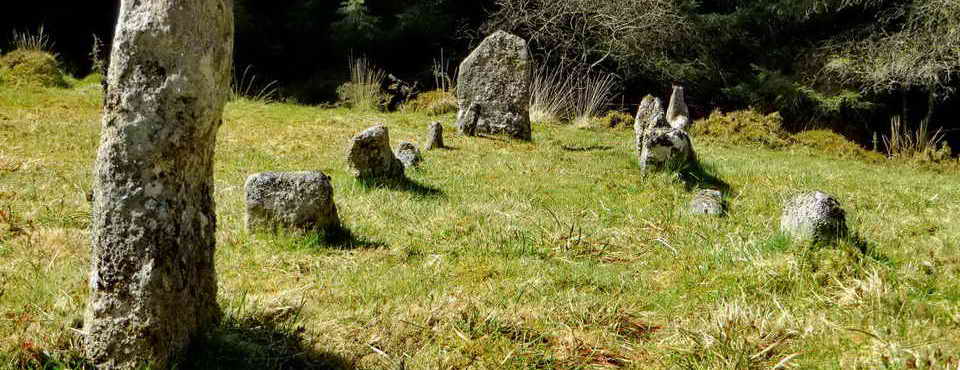
Approaching the 300 yard marker which is which is right by a Bronze Age round house/hut circle, one of 45 hut circles in the area. These are described by J. Butler (1994), Dartmoor Atlas of Antiquities Vol. 3 - The South West, 1 - Hart Tor North (fig. 46.1), pages 53-53.

Closer .....

Closer still, at SX 58138 72392.

No GPS location was recorded for this marker.

The 200 yard marker at SX 58138 72296.

The butt or target backstop on the rifle range, it was probably behind this that whoever manned the targets sheltered because the stone post that is believed to have held the targets is ......

..... off a little to one side, at SX 58152 72126 (marked as BS on the map below).

"Those Labradors can't get up here!", somewhere on Hart Tor.

Zoomed view to Cramber Tor from Hart Tor.

Zoomed view to South Hessary Tor.

Leeden Tor(s).

Leather Tor (left) and Sharpitor (right).

Sheep's Tor.

Approaching The Prince of Wales and our Christmas lunch!

Moor Strollers Christmas lunch at The Prince of Wales, Yelverton (Photo: Hugh).

Receiving plaudits (Photo: Hugh).
MAP: Red = GPS satellite track of the walk.

Ordnance Survey © Crown copyright 2005. All rights reserved. Licence number
100047373.
Also, Copyright © 2005, Memory-Map Europe, with permission.
This walk was accessed from the main car park in Princetown, marked by the yellow cross on the map above.
Statistics
Distance - 5.41 km / 3.36 miles
All photographs on this web site are copyright ©2007-2016 Keith Ryan.
All rights reserved - please email for permissions