![]()


This walk: 2019-2-25. Yellowmeade Farm sign, Mission Hall ruins, leat, Red Cottages, drill stone no. 1, Yellowmeade, split stone, Cake Stone, "sett makers' banker" site, Foggintor Quarry, TA stone gate post, King's Tor or Great King Tor, grooved setts, Eva's or Hill Farm, Wesleyan Chapel, Hill Cottages, lintel, Swell Tor, Big Tip, Manager's house, stables, crane base, "WS 1905" inscription, Royal Marines' rope anchor points, Smithy building, double sett makers' bankers, loading dock, Royal Oak aka Gibbs Cottage, archway, drill stone no. 2, round house (hut circle), explosives store, West Mead Quarry.
Walk details below - Information about the route etc.
Previous walks in this area: 4 Jul. 2007, 10 Mar. 2010, 23 Jul. 2010, 11 May 2011, 8 Jul. 2015, 16 Jul. 2015 (through the quarry, but unintentionally deleted the GPS track)
Reconnaissance walks: 7 Feb. 2019, 11 Feb. 2019.
Old maps .....
OS 25-inch single
sheet Surveyed 1883 Published 1885 - northern half of
Foggintor
OS 25-inch single sheet
Surveyed 1883 Published 1885 - southern half of Foggintor -
zoom in, it's dim
OS 25-inch England & Wales 1841-1952 zoomable whole area map
1840 Walkampton Tithes Map - no sign of the
quarries - because they were not involved with tithing?
Google Satellite map + GPS track of the walk
Further reading
Eric Hemery (1983), Walking the Dartmoor Railroads, David & Charles, Newton Abbot, page 11. Original PDR railhead was at Foggintor Quarry, later it was a depot behind the Railway Inn, later named The Devil's Elbow (next door to The Plume of Feathers, Princetown).
Eric R. Shepherd (1997), The Plymouth & Dartmoor Railway and The Lee Moor Tramway, Ark Publications (Railways), Newton Abbot, Devon.
George Thurlow (1993 & 2001), Thurlow's Dartmoor Companion, Peninsula Press, Newton Abbot, Devon.
Kath Brewer (1997), The Railways, Quarries and Cottages of Foggintor, Orchard Publications, Chudleigh, Newton Abbot, map p. 81. These author and title details appear in The British Library as Journal ISSN: 0309-0728 - same details, but for an Industrial Archaeology Review. VOL 21; NUMBER 1; 1998, 67, not the book.
John Hallet (1994), Around Princetown's Quarries: Tyrwhitt Railway Trail from Princetown, Orchard Publications, Newton Abbot. ISBN 189896405X (pbk)
Legendary Dartmoor - Foggintor web page.
Mary Stanbrook (1991), Old Dartmoor Schools, Remembered, Quay Publications, Brixham.
William Crossing (1966 & 1992),
Crossing's Dartmoor Worker (1st edn),
Peninsula Press, Newton Abbot.
Crossing's
Dartmoor Worker (1966)
first appeared as letters in the Western Morning News, starting in
August 1903. He refers to the first Princetown / Walkhampton quarries as
"starting 80 years ago" (this
equates to 1823). In the chapter entitled
The Quarryman, p. 73-74, he
writes:
"Granite was obtained from Walkhampton Common prior to 1808 for the purposes of
the war prison and barracks" ..... and ..... "The first of the Walkhampton Common quarries to have been opened .......
Royal
Oak and the other, a short distance from it ..........Higher
Quarry ....... Close by was a row of
dwellings ...... Red Cottages." p.70.

The Yellowmeade sign - this is across the track from the small car park that is marked on old maps as "Sand pit" .....
Devon & Dartmoor HER - MDV51401 -
Old sand pit beside road north of Walkhampton Common,
see also pits at Wheal Lucky .....
Devon & Dartmoor HER - MDV
51402 -
Extractive pits along road north of Walkhampton Common

Across the road from the Yellowmeade track are the ruins of the old non-denominational Mission Hall, built 1887, demolished 1965 (Stanbrook p.95). Due to problems at Foggintor school, the hall opened as a school on 17th August 1896 with 41 pupils. By 1895, there were 95 children. The school closed on 27th September 1912. The children went to temporary schools at Merrivale and back at Foggintor Chapel until the new school opened at what is now known as Four Winds, on 19th April 1915. Source: M. Stanbrook, pages 95-103 (there is a photograph of the Mission Hall on page 99). In the photograph above, Great Mis Tor is seen at top right.

Another view.

Just above the car park is the leat that supplied Red Cottages (where the fir trees are), still supplies Yellowmeade and formerly ran on to supply Foggintor. It is probable that the cottages were supplied by a bullseye stone so as to conserve the water.

The site of Red Cottages - The cottages stood on the high ground on the left of the photograph and were separated from their gardens by a back lane. The cottages were planned in 1846 and built by April 1849 (Kath Brewer, pages 94-95). They were probably demolished in 1953, the same year as Hill Cottages.
According to various Censuses, they were originally known as Mount Pleasant Cottages, then West View Cottages, and after that, Red Cottages. They were built with cob and by 1871 the weather got into them so badly they were "covered with corrugated iron" and painted with red lead, thus becoming known as Red Cottages - this appears in the 1871 Census. Kath Brewer writes that in later years they were actually black, having been covered with pitch, again against the weather, thus becoming black cottages! There were six cottages but with twelve dwellings - with "one up, one down". In the 1861 Census, there were thirteen families with 50 adults and 38 children at West View, as the cottages were known at that time! This reflects the importance of quarrying in the area - at one time there were approximately 600 men employed in all the quarries in the area Source: Stephen Woods (1988), Dartmoor Stone, Devon Books, Exeter, page 283.

Google Earth image showing Red Cottages (top tight) and the proximity of West Mead Quarry (lower left). Image from Google Earth (c) 2017.

Some of the gateposts.

The first of two drill testing stones embedded in the track, this one is located at SX 56618 74485.

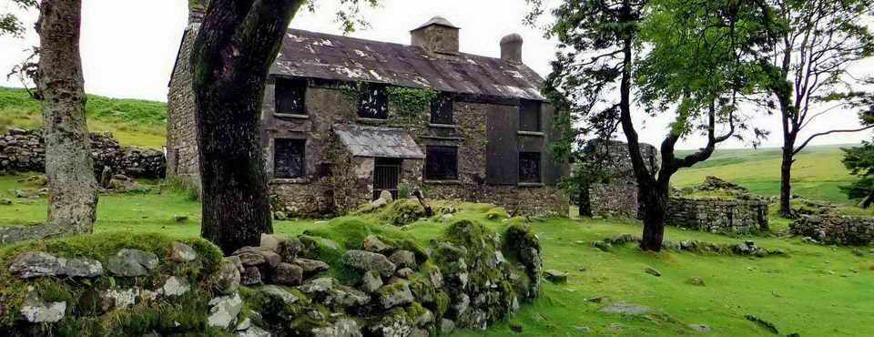
Approaching Yellowmeade. The "lumps and bumps" in the background are waste tips of Foggintor Quarry. "Yellowmeade farm itself was not established until 1860, the last farm to be founded in Walkhampton Parish" - Dave Brewer (1986). A Field Guide to the Boundary Markers on and around Dartmoor, Devon Books, Exeter, page 70. It was enclosed by George Cole (Hemery, p.1027). The family lived there until about 2015.

Looking at granite setts in the railway (actually a horse-drawn tramway) built sometime after 1823 after the Plymouth & Dartmoor Railway was opened to the King Tor quarries. The railway was extended to Princetown in Dec. 1826 by which time it could have been built to serve Swelltor and Fogginror quarries. The railway was built by Sir Thomas Tyrwhitt to serve the quarries as a business venture.

Stone at SX 56718 74141, split by feather and tear and held open with a stone wedge?

The Cake Stone - a granite block abandoned in the process of splitting for making setts for the railway - this stone would have provided eight setts .....

Ditto - from another angle.

A "sett makers' banker" at SX 56737 74084: this is not the classic arrangement but the waste that is typical of the process is clear in this and the next photograph ......

As previous photograph - a site where no doubt setts were made for the railway that was being built along the track in the background.

A general view of Foggintor from the sett making site above - the "bumps" on the left skyline are high-level waste tips while the enormous waste tip to the right is named "Big Tip". Foggintor Quarry was also known at various times as Royal Oak Quarry, Hill Quarry and Foggator (at Foggin Tor). It began commercially around 1823, as did several other quarries in the area. Little King Tor and Great King Tor quarries were already working and Tyrwhitt's railway terminated at them originally, in 1823. (Hallett p.35). The "bumps" on the skyline at the right are waste tips at Swell Tor Quarry. Foggintor Quarry closed in 1906, when 40 men were employed. A factor was competition from cheaper sources and the use of concrete in building. At one time, in the 1830s and 1840s, 600 men employed. (Hallett, p35)

As previous photograph - a zoomed view of ruins at Hill Cottages.

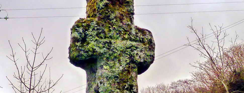
The TA stone (the Medieval Tavistock-Ashburton packhorse track) incorporated into a now-blocked up gateway, at SX 56718 74141. This is in the angle between two walls below the track. An iron gate hanger is still on position on the left post.

A would-be "cist" at SX 56710 73981 - North Hessary Tor tv mast on the skyline .....

This odd feature again, with Great King Tor (from the Tithe Map) in the background. The blocked-up gateway with the TA stone post (see 2nd photograph above) is seen in the wall angle near the right edge of the photograph.

Worn or "worked" tramway setts at SX 56708 73953.

Zoomed view to Hill Farm at Foggintor, also known as Eva's Farm ..... the family was at Foggintor on 1881 Census - at the Farm in 1891 Census - family there until at least 1936. (Kath Brewer, p.86-87 & 115).

Hill Farm gate posts, with Middle Staple, Great Staple and Roose Tors in the distance.

Central area of the photograph - the ruins of Foggintor Wesleyan Methodist chapel which later became variously a school, living quarters, a school again (1913-1915, after Mission Hall became unsuitable), a workshop and then a private dwelling. Source: M. Stanbrook, p.95.

Ruins at Hill Cottages, Foggintor, with King's Tor in the distance ..... In 1861 (Census), 267 people were living at Foggintor.
Notes added 27 June 2020 .....
|
BBC Spotight 1954 film
- A Brief Journey ..... BBC
Spotlight revisits the 1954 film "A Brief Journey" in 2018 ..... |

Overlooking the Manager's house (the flat grassy site in the centre) and ruins of the horse stables, beyond .....

Another view. It seems likely that the rocky protuberance on the skyline is actually Crip Tor - as it was placed on the Tithe map in 1840 (see which below).

".......... and today, we are looking through the oblong window at Big Tip with Swell Tor, beyond."

Lintel, mantel or clavel from a fireplace in Hill Cottages .....

A view looking from the northern quarry entrance, between the cottages, out Big Tip - a branch railway line was laid out here to carry waste for tipping. The railway gauge was about 2-feet for easy man-handling. It is writ that only 10% of quarried granite was used in building, the rest was waste .....

Looking in the opposite direction, into the northern entrance to the quarry, with the remains of a crane base in the foreground, SX 56652 73658. Thurlow (p. 313. see Books above) - Foggintor Quarry - originally called Royal Oak, opened 1820. The original tramway (Thomas Tyrwhitt's, opened 1823), preceding the Princetown Railway (which became GWR) ran from this area. See ..... also known as Hill Quarry (hence Hill Cottages), Foggator as well as Foggintor. Foggintor stone believed used in Thomas Tyrwhitt's Tor Royal at Prince's Town, started 1785 and completed in 1798, after 13 years. One of the earliest examples of local quarrying. The war prison was built 1806-1809 (Prison Quarry opened soon afterwards). (Hallett p.35)
Johnson Brothers leased Foggintor. In 1840 they also leased Haytor Quarries from the Duke of Somerset and immediately closed them. They then traded Foggintor stone under the Haytor Granite Co. name. Seven years later, the Duke refused to extend their lease!
Devon & Dartmoor HER - MDV 5005 - Foggintor Quarry, Princetown - good detail and further links

The WS 1903 inscription just inside the entrance into the quarry.
Starting the circuit around the rim of the quarry .....

Panorama photographed against the sun, showing the ruins of Hill Cottages and Big Tip at the right, the "first", northern entrance into the quarry (the crane base is halfway along) and the flooded section of the quarry at the left. Click the image to see a larger version (with unnatural colours).

View across the quarry from the 9 o'clock (north) position. The "first", northern entrance is to the right, the second entrance is in the centre of the view (out of sight, to the right). The site of a building can be seen left of centre, in the shadow near the bottom of the photograph. Click the image to see a larger version.

Not far from the start of the circuit of the perimeter of the quarry. The "first", northern entrance, is down to the right, off the photograph. In the distance, right of centre, is King's Tor with the old railway line running straight across part of the scene. On the skyline to the right, is Swell Tor.

A well-preserved crane base in the quarry - one of seven, apparently.

View from the 12 o'clock (east) position, towards the two entrances to the quarry - they are roughly 1/4 and 1/2 way in from the left. Click the image to see a larger version.

Rope anchor points for the Royal Marines - some others can be seen across the quarry.

Looking north, across the quarry towards Yellowmeade, with the two fir trees at Red Cottages behind.

Looking down into the quarry from a quite high vantage point - at two crane bases (with yellow "v" labels).

Looking down from SX 56718 73435 onto a crane base and a sett makers' banker .....

As previous photograph - a sett makers banker.

The Smithy, at the southern entrance into the quarry, SX 56549 73458.

A pair of sett makers' bankers, between the "second" (southern) quarry entrance and the end of the Loading Dock, at SX 56583 73520.

To the right of the track above is a section of wall that was the Loading Dock. There is a building on Roborough Common that was part of the 1823 railway where horses were changed which is known as "The Wharf" (there is a photograph in Shepherd p.15).

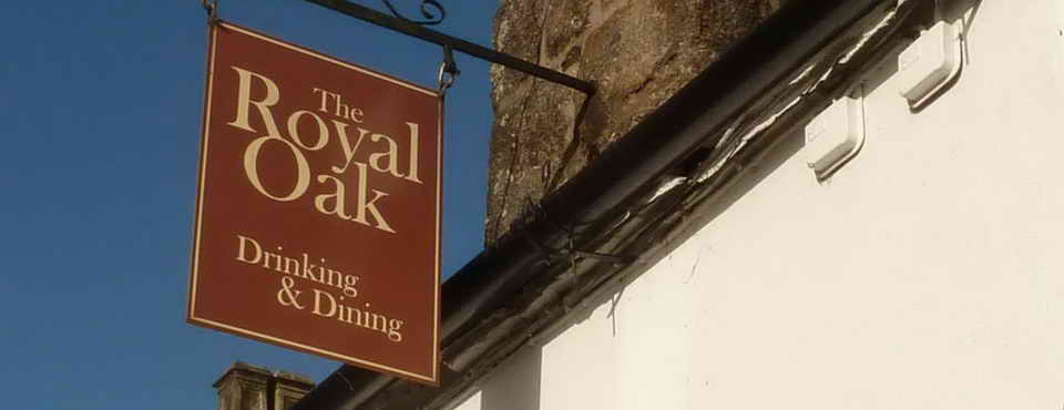
Gibbs Cottage, on the site that was formerly the weighbridge. This has also been described as Royal Oak Bungalows - Foggintor being known once as Royal Oak Quarry, also as Hill Quarry.

King Tor.

The group of 29 at Foggintor ..... 25th February - some with sun hats and short sleeves!

Copyright - Devon County Council
The 1840 Walkhampton Tithe Map shows Little King Tor and Great King Tor. It also shows the 1823 Plymouth & Dartmoor Railway, extended from King Tor quarries to Princetown in Dec.1826, it shows neither Foggin Tor nor the branch line to Foggintor Quarry. These were active well within Walkhampton Parish, although quarrying had nothing to do with tithing and therefore wasn't suitable for the purpose of the map. Note also the position of Crip Tor.

Another view of the stables.

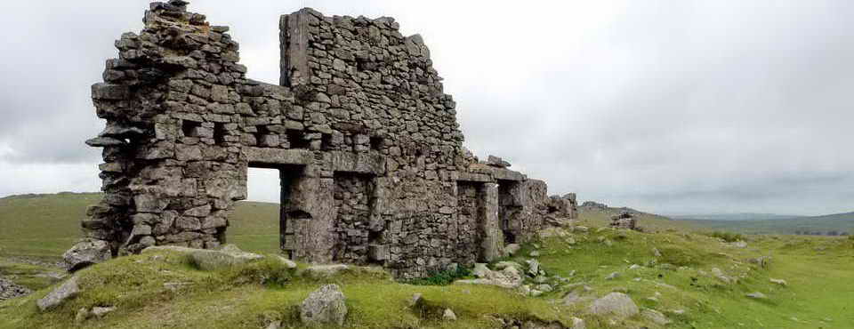
A different view of the dramatic ruins at Hill Cottages. This is particularly poignant because the cottage above the arch was home to Kath Brewer, author of The Railways, Quarries and Cottages of Foggintor, Orchard Publications, Chudleigh, Newton Abbot, 1997. The cottages are believed built in the 1840's and the last resident left in 1951 and they were demolished in 1953.

The purpose of the arch is unknown - there is a suggestion that perhaps a waterwheel was located here but there seems to be no real evidence.

The second drill testing stone, embedded in the railway track, at SX 56671 73777, in sight of Hill Cottages. Later, on 2019-7-12: 56669 73777±2 metres.

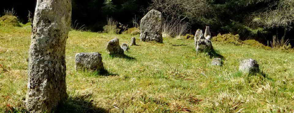
A round house / hut circle in the Bronze Age enclosure at SX 56412 74503, below the track from Yellowmeade to Red Cottages; this hut is labelled "1" in the figure below ..... cairn 1 is a ruined cisted cairn ..... we visited the robbed hut 9 and looked for cairn 2 .....

Image © J Butler
1994. Reproduced by kind permission (ref. 29 Sept. 2012).
The area around Yellowmeade was occupied in Bronze Age times and is described in Jeremy Butler, 1994, Dartmoor Atlas of Antiquities Vol. 3 - The South-West,1: Yellowmeade (figs. 44.1,1.1,1.3), pages 14-21.

Explosives store for West Mead Quarry, at SX 56450 74621 ..... Four Winds car park in the background .....

Looking across the entrance to West Mead Quarry at the ruins of its buildings. These included a blacksmith's shop and a crane platform and possibly a compressor base for air tools.

View from the head of the quarry out through the entrance. The quarry closed in 1966.
Devon & Dartmoor Historic Environment Record - MDV21128 Remains of Red Cottages, Walkhampton Common
Devon & Dartmoor Historic Environment Record - MDV117446 Hill Cottages at Foggintor Quarry
Devon & Dartmoor Historic Environment Record - MDV5005 Foggintor Quarry, Princetown .....
Royal Oak Quarry (later known as Foggintor) was worked from the early 19th century until the early 20th century, extracting granite that was taken away on the nearby railway line. Remains on the site include ruins of numerous buildings, large spoil tips and tracks, including that leading to the nearby Swell Tor Quarry, was closely associated. Foggintor was known to have included up to 30 cottages, Manager's house, smithy, powder house, dressing sheds and stables. A Wesleyan chapel was built 1883. In peak year of 1861, 183 people were supported.
Devon & Dartmoor Historic Environment Record - MDV28208 Buildings at Foggintor Quarry - scant record
Devon & Dartmoor Historic Environment Record - MDV28206 Building at Foggintor Quarry - very scant record
Pastscape - Monument number SX 57 SE 277 - Foggintor Granite Quarry - worth a look.
Other search results
| Search results | |
|---|---|
| Name | Location |
| Gardens west of Red Cottages, Walkhampton Common | Dartmoor Forest |
| ENCLOSURE in the Parish of Dartmoor Forest | Dartmoor Forest |
| Hut circle in settlement north-west of Yellowmead Farm | Dartmoor Forest |
| Hill Cottages at Foggintor Quarry | Dartmoor Forest |
| Foggintor Quarry, Princetown | Dartmoor Forest |
| Methodist chapel / school at Foggintor Quarry | Dartmoor Forest |
MAP: Red = GPS satellite track of the walk.

Crown copyright 2016 Ordnance
Survey
Licence number 100047373
Also, Copyright © 2005, Memory-Map Europe, with permission.
This walk was reached using the B3357 and between Tavistock and Two Bridges. Car parking was at the small quarry seen on turning into the track to Yellowmeade Farm the P symbol on the map and across the road from there, by the ruins of Foggintor Mission Hall. There is also some space up the hill at the old Pump House.
Statistics
Distance - 4.5 km / 2.8 miles
All photographs on this web site are copyright
© Keith Ryan.
All rights reserved - please
email for permissions